If you like to do challenges like these, a couple of fun ones:
- bike/walk/run every street in your city. Can use for instance https://wandrer.earth/ with Strava to track it. It's quite nice, discover all kinds of things in my own neighborhood I didn't know of. By habit you always take the same routes. This makes me take a new road on my way back home and see new stuff.
- Draw art on the maps using gps. I've done multiple. Takes planning and often a few attempts executing when you realize that road is closed, that path was flooded or whatever. I've even gotten in the news a few times from this. For instance when I ran this pest doctor during lock downs https://imgur.com/a/qRkB5QN
- Bike the longest distance using the smallest area. Basically find a roundabout and see how long you can take it. Or the opposite, the largest area in your city, basically bike its border.
Bit offtopic, but if live in a big city, you don't even need to visit every street, just visiting every neighborhood might be insighful.
My wife and I are looking to move back to my home town possibly next year after 10 years abroad, and we are checking all kind of online resources about the city.
Is wild to me that a random expat on Youtube is teaching me all kind of things that I didn't know about my own city. I guess the almost 30 years I spent there I really only frequented a very small section of it, and entire sections of the city are complete blind spots.
What I really want is "nice" cycling routes, and then doing the longest paths. Many times I've tried to find the longest path that doesn't repeat from my house where I do not intersect with automobile traffic, or taking low-traffic streets without any major intersections. It's tough to get far this way, but competing for space with cars is just so stressful, so it's why I don't do things like ride the perimeter of my city. It's just not very conducive to keeping my bones intact.
> competing for space with cars is just so stressful, so it's why I don't do things like ride the perimeter of my city
In my city (Denver) there's an independent group that keeps a map of low-stress streets to ride on (which they share as a google map plus phone apps), which is different than the official bike routes map put out by the city.
https://www.bikestreets.com/maps It includes some off-street routes outside to the city limits but just looking at the ones within the city, there might be a nice route to try out for me.
The Citymapper app has been awesome to find routes through my city that I never would have found. It made biking as a car replacement far easier and significantly more fun.
Note that for really long rides, it is best to map segments of it in chunks to avoid main roads.
My goal is to make walks to satisfy my daily minimum of 6,000 steps, up to maybe 10,000 or 12,000 steps with outlier days up to 30k~35k steps. I live in an area I would describe as having moderate walkability: neighborhoods where it's not much of a problem, bigger streets with sidewalks, but also stroads and highways that I need to mostly avoid. And due to the obvious constraints of my home being in a fixed place, I feel I have completely exhausted my options. I get so bored from doing the (mostly) same variations. To be even harder on myself, I hate using the same in and out route, so instead of finding 3k steps worth of "excitement", I pretty much need double that to satisfy my craving :-D
This is why I loved Bo Burnham's "Inside". Laughed so much at that film when it first came out. Nowadays it almost gives me flashbacks.
This is basically how I did lockdown as well. The result was a web app called VOS where you can plan walks which help you wrap your head around astronomical scales:
Back when I was into programming contests, I wrote a program to find the smallest selection of cities, the letters of which would cover the alphabet in correct order.
I even felt a small urge to take pictures of the place name signs of those cities and turn it into art. Soon after that stroke of genius thought, I stumbled upon an exhibition by a Dutch artist [1] who visited nearly every city in The Netherlands, took a picture of himself, his car, and the place name sign, and I lost interest.
Obviously I got the inspiration in an Amsterdam metro line that stops at ABCOUDE [2].
It might be interesting to retry this with the entire OpenStreetMap database.
[1] Forgot his name, can't find it on the internet, ChatGPT has no clue.
There is a big tension in the UK between people who use kilometres by default, and those who miles.
Although road-signs are all in miles, it's not unknown for other distance markers (e.g. on walking / cycling trails) to be in kilometres. When I was studying in Birmingham in 2006-2010 the signs on the canal network were in kilometres.
For me, my default unit is kilometeres (although I am one of those awful Bremoaners [https://en.wiktionary.org/wiki/Bremoaner] who even moved to Berlin after the vote).
Right, the law mostly says to use metric units, except it has specific derogations for some of the road signs to be in miles. So the canal and walking route signs should - especially if put up by some authority rather than informally - be metric, whereas road signs mustn't be in the same circumstances.
Same for booze. It's illegal to sell most booze in imperial units (e.g. a shot of whiskey must be either 25ml or 35ml, no other values, and the choice between 25ml and 35ml shot size is for an entire bar, they can't be like house vodka is 35ml but this expensive Scotch is 25ml), but, it's mandatory to sell beer and cider by the pint.
It's a temporary fudge that then politicians are reluctant to actually follow through and do the clean-up later because that's only going to annoy the handful of strong opponents and makes little real difference to ordinary punters for whom this isn't a priority.
Sometimes this works out OK in politics, e.g. in Britain it was never strictly made illegal to sell leaded fuel only new cars which need such fuel - but it soon made no economic sense to make such fuel as a fuel refinery, so the ban was unnecessary. Politicians could go from telling the niche of pro-lead constituents they'll still be able to buy the fuel they want to commiserating them that it's no longer for sale, never having actually banned it.
> but, it's mandatory to sell beer and cider by the pint.
Is it? Is it not 568ml of beer? I.e. not sold as an imperial pint measure, but as 568ml?
Of course everyone calls it a pint of this or the other, but I think on all the glasses etc the measures are in ml not imperial pints? It's been a while since I've been to a pub (before COVID) so I guess this might have been rolled back after Brexit?
No, a pint. A pint isn't 586ml it's 568.26125ml. Nobody does non-SI metrication, metrication is very expensive, the world pays for it collectively, and so it's done for the SI unit system because nobody wants to subsidise anybody else's weird local units. As a result if you have weird units (as the Americans do and we do) you have to define them in terms of SI unless you either don't care what they mean (not going to be much use for a weights and measures law are they?) or you've got several billion dollars to pay to duplicate that work.
The only place a pint is legal is draught beer and cider, which are poured into glasses and the glasses are marked either with a line or "to the brim", with either a crown mark or a CE label signifying the maker claims these glasses comply with regulations.
The people making a "beer glass" and putting the crown mark on it need to ensure it conforms, if they've got gear that can tell them it's 568.26125ml that'd work, because that's what a pint is, but the law says "Pint", not "568.26125ml".
Happy to see Diziet has published this after our discussion in the pub a couple of nights ago.
The only thing that surprises me is that it wasn’t fanf2 who submitted it. :-)
One thing I didn't appreciate until too late when moving out of the UK post-Brexit was quite how unusually densely packed the Cambridge geek circles are; seeing this username again, yours as well I think, fanf of course, and honestly half the people who used to go to The Carlton before the fire…
I was expecting it to be that easy to surround myself with similar people here, but apparently not.
I did jury duty at the Crown Court a few years ago, and met a Debian maintainer and MSR researcher over the course of a week. And far more oddly, I met a friend of one of the Dasher developers who saw me using it to reply to some mail because my keyboard had broken.
In a jury lounge with around fifty randomly selected strangers this doesn't seem probable, and I can't imagine a similar outcome if I'd been at Bedford(which I think is the next closest crown court).
I'm more accepting of bumping in to fellow travellers at the curry house or pub, because we're choosing to go where others suggest. Still, Cambridge is joyously weird.
Note to self: Probably should have used the jury duty downtime to meet some interesting "normal" people though.
There are definitely other circles of people round the world, but they generally don’t have that same element of, “you can turn up at this place on this evening and probably meet somebody you want to talk to.”
I think it’s an intrinsic thing with British pub culture, the same can be applied to various genres of literature, game design, films, and so many other things.
This video is what got me to start doing pac-man style running in Santa Clara at the start of 2023 after doing the same routes here for a few years. Highly recommend.
The rides are cool and it sounds like a fun project. I was a bit caught by surprise at the mention of being told not to go far from your house during COVID. Different parts of the world handled that very differently.
Cambridge itself varies from a little less than 10m above sea level to a little more than 20m above sea level. I think the highest point of Diziet’s rides was probably Royston, getting on for 100m above sea level. Lowest point probably near Soham, a few metres below sea level. Not Soham itself: the fenland towns are slightly evevated, enough that they flood less than the surrounding area.
Fun fact: in Cambridge city centre there are several streets called things like Market Hill and Senate House Hill. They are called “hills” because they used to be about 0.5m higher than other nearby streets. The difference is most visible on Benet St where there are steps from the road (gradually raised over the centuries) down to the churchyard around the tower, which is the oldest building in Cambridge, about 1000 years old.
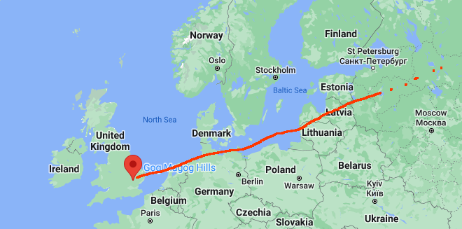
Second fun fact: the Gog Magog hills outside Cambridge are the highest point between there and some insane distance to the NE.
How can this be, you ask incredulously? It's almost entirely open water between those two locations, other than incredibly flat land as you cross eastern England and ditto before reaching wherever the next spot that is above 300'.
If you head northeast from the Gog Magog hills you will stay over land. The longest you can go in that direction without exceeding 75m elevation is I think about 200km, going just to the east of Peterborough and Lincoln, over the Humber to a liitle place north of Market Weighton called Londesborough, roughly halfway between York and Hull. East of Lincoln there's a long valley that's very nicely aligned so that our line can slip between the Lincoln Edge and the Lincolnshire wolds.
>With a modal share of 7% (2018), Oslo’s bicycle strategy has a modal share target for cycling of 16% by 2025. Furthermore, Oslo has seen a ten-fold increase in the annual construction of bicycle infrastructure, from 1.5 km/year to over 15 km/year, with an updated mandate to build 100 km for the period 2020-2023.
>Oslo has a strong focus on road maintenance, which complemented by winter cycling campaigns, has drastically contributed to higher numbers of winter cyclists. A priority network of bike lanes was established for high-level winter maintenance, which in its first three years of operation has resulted in an 78% increase in cycling traffic during the winter months.
It turns out that when you consider "how will people cycle in the winter" as a problem to be solved, rather than simply an excuse for doing nothing, you can dramatically improve your city. Amazingly, when you treat cycling as a first class citizen in the transportation network, and keep the cycle lanes in proper condition rather than abandoning them to the elements the second things get tough, people will use them year round even in cold climates.
And while they did this, they cut pedestrian and cyclist fatalities down to zero. Any city can do this, if it actually tries.
- bike/walk/run every street in your city. Can use for instance https://wandrer.earth/ with Strava to track it. It's quite nice, discover all kinds of things in my own neighborhood I didn't know of. By habit you always take the same routes. This makes me take a new road on my way back home and see new stuff.
- Draw art on the maps using gps. I've done multiple. Takes planning and often a few attempts executing when you realize that road is closed, that path was flooded or whatever. I've even gotten in the news a few times from this. For instance when I ran this pest doctor during lock downs https://imgur.com/a/qRkB5QN
- Bike the longest distance using the smallest area. Basically find a roundabout and see how long you can take it. Or the opposite, the largest area in your city, basically bike its border.